Soil Surveys, Environmental Assessment & Land Management

Agricultural Land Classification Maps
Agricultural land classification maps are vital tools in environmental planning, agricultural management, and land use policy. These maps categorise land based on its suitability for agriculture, considering factors like soil quality, climate, topography, and water availability.
The only way to accurately determine the agricultural grade of the land is by getting a detailed field survey. This information is combined with climatic and other data to produce an ALC map and report. These ALC assessments are then used to support planning decisions. Most ALC Maps are based on the principles of the Agricultural Land Classification System of England & Wales.
As mentioned in the Agricultural Land Classification of England and Wales document, “small, discrete areas of a different ALC grade may be identified on large scale maps, whereas on smaller-scale maps it may only be feasible to show the predominant grade.”
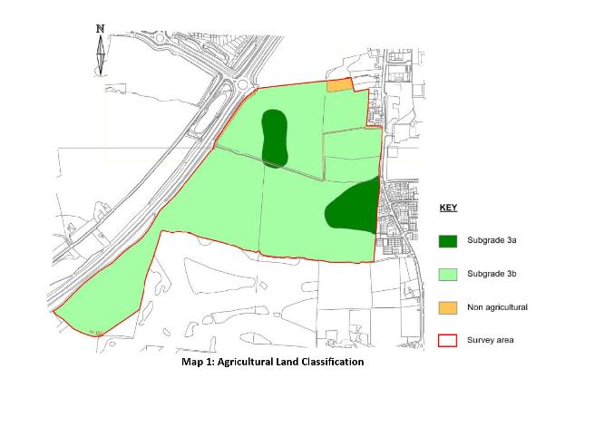
Find out more about the agricultural land grades marked on a map like the one below.
Key Features of Agricultural Land Classification Maps
- Soil Quality Assessment: Evaluates soil types, fertility, and drainage capabilities, which are crucial for determining agricultural potential.
- Climate Analysis: Incorporates climate data, such as rainfall patterns and temperature ranges, to assess the viability of different types of crops.
- Topographical Details: Maps include topographical information like elevation, slope, and aspect, which affect sunlight exposure and drainage, impacting agricultural suitability.
- Water Resource Mapping: Identifies water sources and their accessibility, a critical factor for irrigation and sustainable agriculture.
- Land Use History: Historical land use data can provide insights into past agricultural practices and their outcomes, informing future use.
Applications
- Agricultural Planning: Helps farmers and agricultural businesses to identify the most suitable areas for different types of crops and livestock.
- Environmental Conservation: Assists in identifying areas where agriculture might negatively impact ecosystems, guiding sustainable land use practices.
- Policy Making and Zoning: Influential in government decision-making, particularly in zoning laws and agricultural subsidies.
- Urban Planning: Ensures that urban expansion does not encroach on high-quality agricultural land, maintaining a balance between development and food security.
Future Directions
The integration of advanced technologies like remote sensing, GIS (Geographic Information Systems), and AI (Artificial Intelligence) is enhancing the accuracy and usability of agricultural land classification maps. These technologies enable real-time monitoring and predictive analytics, providing a more dynamic and responsive approach to agricultural land management.
Agricultural land classification maps are more than just charts; they are essential tools for sustainable agricultural development, environmental conservation, and efficient land use planning. As technology evolves, these maps are set to become even more integral in managing the delicate balance between human needs and environmental conservation.